When making financial decisions, it’s important to look at the big picture — say, one taken from a drone, satellite or AI-powered sensor.
The emerging field of spatial finance harnesses AI insights from remote sensors and aerial imagery to help banks, insurers, investment firms and businesses analyze risks and opportunities, enable new services and products, measure the environmental impact of their holdings, and assess damage after a crisis.
Spatial finance applications include monitoring assets, modeling energy efficiency, tracking emissions and pollution, detecting illegal mining and deforestation, and analyzing the risks of natural disasters. NVIDIA AI software and hardware can help the industry combine their business data with geospatial data to accelerate these applications.
By better understanding the environmental and social risks associated with an investment, the financial sector can choose to prioritize those that are more likely to support sustainable development — a framework known as environmental, social and governance (ESG).
Focus on sustainable investments is growing: A Bloomberg Intelligence analysis estimated that ESG assets will represent more than a third of total managed assets worldwide by 2025. And a report by the European Union Agency for the Space Programme predicts that the insurance and finance industry will become the top consumer of Earth observation data and services over the next decade — resulting in more than $1 billion in total revenue by 2031.
Several members of NVIDIA Inception, a global program that supports cutting-edge startups, are advancing these efforts with GPU-accelerated AI applications that can track water pollution near industrial plants, quantify the financial risk of wildfires, assess damage after storms and more.
Powerful Compute for Large-Scale Data
GPU-accelerated AI and data science can rapidly extract insights from complex, unstructured data — enabling banks and businesses to set up real-time streaming and analysis of data as it’s captured from satellites, drones, antennas and edge sensors.
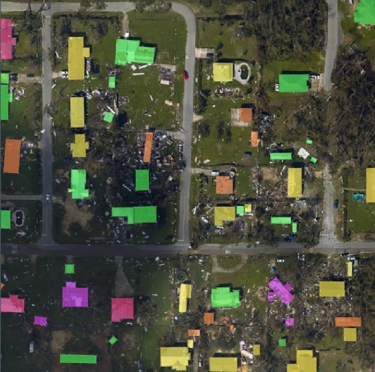
By monitoring aerial imagery — available for free from public space agencies, or at higher granularity from private companies — analysts can get a clear view of how much water is being used from a reservoir over time, how many trees are being cut down for a construction project or how many homes were damaged by a tornado.
This capability can help audit investments by verifying the accuracy of written records such as government-mandated disclosures, environmental impact reports or even insurance claims.
For example, investors might track the supply chain of a company that reports it has achieved net zero in its production line, and discover that it actually relies on an overseas plant emitting coal ash visible in satellite images. Or, sensors that analyze heat emissions from buildings could help identify low-emitting businesses for a tax credit.
NVIDIA’s edge computing solutions, including the NVIDIA Jetson platform for autonomous machines and other embedded applications, are powering numerous AI initiatives in spatial finance.
In addition to using NVIDIA hardware to speed up their applications, developers are adopting software including the NVIDIA DeepStream software development kit for streaming analytics, part of the NVIDIA Metropolis platform for vision AI. They’re also using the NVIDIA Omniverse platform for building and operating metaverse applications for detailed, 3D visualizations of geospatial data.
Insuring Property — From Assessing Risks to Accelerating Claims
NVIDIA Inception members are developing GPU-accelerated applications that turn geospatial data into insights for insurance companies, reducing the number of expensive onsite visits needed to monitor the status of insured properties.
RSS-Hydro, based in Luxembourg, uses GPU computing on premises and in the cloud to train FloodSENS, a machine learning app that maps flood impact from satellite images. The company also uses NVIDIA Omniverse to animate FloodSENS in 3D, helping the team more effectively communicate flood risks and inform resource allocation planning during emergencies.
Toronto-based Ecopia AI uses deep learning-based mapping systems to mine geospatial data, helping to produce next-generation digital maps with highly accurate segmentation of buildings, roads, forests and more. These maps power diverse applications across the public and private sectors, including government climate resilience initiatives and insurance risk assessment. Ecopia uses NVIDIA GPUs to develop its AI models.
CrowdAI, based in the San Francisco Bay Area, uses deep learning tools to accelerate the insurance claims process by automatically analyzing aerial images and videos to detect assets that were damaged or destroyed in natural disasters. The company uses NVIDIA GPUs for both training and inference.
Predicting Risks and Opportunities for Businesses
Inception startups are also using geospatial data to help government groups and banks quantify the risks and opportunities of their investments — such as predicting crop yields, detecting industrial pollution and measuring the land and water use of an asset.
Switzerland-based Picterra is supporting sustainable finance with a geospatial MLOps platform that enables banks, insurance companies and financial consultancies to analyze ESG metrics. The company’s AI-driven insights can help the financial industry make investment decisions, model risk and quickly quantify vulnerabilities and opportunities in investment portfolios. The company uses NVIDIA Tensor Core GPUs and the NVIDIA CUDA Toolkit to develop its AI models, which process raw data from satellite, drone and aerial imagery.
London-based Satellite Vu, a startup applying satellite technology to address global challenges, will be able to monitor the temperature of any building on the planet in near real time using infrared camera data. These infrared images will provide its customers with insights about the economic activity, the energy efficiency of buildings, the urban heat island effect and more.
And Sourcenergy, based in Houston, uses geospatial data to power an energy supply chain intelligence platform that can help the financial services industry with market research. Its AI tools, developed using NVIDIA A100 GPUs, enable investors to independently create real-time models of energy companies’ well inventories and project costs, giving them insights even before the companies share data in their quarterly earnings reports.
Learn more about NVIDIA’s work in financial services, and read more on geospatial AI in investment management in chapter 10 of this handbook.