How xarvio Digital Farming Solutions accelerates its development with Amazon SageMaker geospatial capabilities

How xarvio Digital Farming Solutions accelerates its development with Amazon SageMaker geospatial capabilities

This is a guest post co-written by Julian Blau, Data Scientist at xarvio Digital Farming Solutions; BASF Digital Farming GmbH, and Antonio Rodriguez, AI/ML Specialist Solutions Architect at AWS

xarvio Digital Farming Solutions is a brand from BASF Digital Farming GmbH, which is part of BASF Agricultural Solutions division. xarvio Digital Farming Solutions offers precision digital farming products to help farmers optimize crop production. Available globally, xarvio products use machine learning (ML), image recognition technology, and advanced crop and disease models, in combination with data from satellites and weather station devices, to deliver accurate and timely agronomic recommendations to manage the needs of individual fields. xarvio products are tailored to local farming conditions, can monitor growth stages, and recognize diseases and pests. They increase efficiency, save time, reduce risks, and provide higher reliability for planning and decision-making—all while contributing to sustainable agriculture.

We work with different geospatial data, including satellite imagery of the areas where our users’ fields are located, for some of our use cases. Therefore, we use and process hundreds of large image files daily. Initially, we had to invest a lot of manual work and effort to ingest, process, and analyze this data using third-party tools, open-source libraries, or general-purpose cloud services. In some instances, this could take up to 2 months for us to build the pipelines for each specific project. Now, by utilizing the geospatial capabilities of Amazon SageMaker, we have reduced this time to just 1–2 weeks.

This time-saving is the result of automating the geospatial data pipelines to deliver our use cases more efficiently, along with using built-in reusable components for speeding up and improving similar projects in other geographical areas, while applying the same proven steps for other use cases based on similar data.

In this post, we go through an example use case to describe some of the techniques we commonly use, and show how implementing these using SageMaker geospatial functionalities in combination with other SageMaker features delivers measurable benefits. We also include code examples so you can adapt these to your own specific use cases.

Overview of solution

A typical remote sensing project for developing new solutions requires a step-by-step analysis of imagery taken by optical satellites such as Sentinel or Landsat, in combination with other data, including weather forecasts or specific field properties. The satellite images provide us with valuable information used in our digital farming solutions to help our users accomplish various tasks:

  • Detecting diseases early in their fields
  • Planning the right nutrition and treatments to be applied
  • Getting insights on weather and water for planning irrigation
  • Predicting crop yield
  • Performing other crop management tasks

To achieve these goals, our analyses typically require preprocessing of the satellite images with different techniques that are common in the geospatial domain.

To demonstrate the capabilities of SageMaker geospatial, we experimented with identifying agricultural fields through ML segmentation models. Additionally, we explored the preexisting SageMaker geospatial models and the bring your own model (BYOM) functionality on geospatial tasks such as land use and land cover classification, or crop classification, often requiring panoptic or semantic segmentation techniques as additional steps in the process.

In the following sections, we go through some examples of how to perform these steps with SageMaker geospatial capabilities. You can also follow these in the end-to-end example notebook available in the following GitHub repository.

As previously mentioned, we selected the land cover classification use case, which consists of identifying the type of physical coverage that we have on a given geographical area on the earth’s surface, organized on a set of classes including vegetation, water, or snow. This high-resolution classification allows us to detect the details for the location of the fields and its surroundings with high accuracy, which can be later chained with other analyses such as change detection in crop classification.

Client setup

First, let’s assume we have users with crops being cultivated in a given geographical area that we can identify within a polygon of geospatial coordinates. For this post, we define an example area over Germany. We can also define a given time range, for example in the first months of 2022. See the following code:

### Coordinates for the polygon of your area of interest...
coordinates = [
    [9.181602157004177, 53.14038825707946],
    [9.181602157004177, 52.30629767547948],
    [10.587520893823973, 52.30629767547948],
    [10.587520893823973, 53.14038825707946],
    [9.181602157004177, 53.14038825707946],
]
### Time-range of interest...
time_start = "2022-01-01T12:00:00Z"
time_end = "2022-05-01T12:00:00Z"

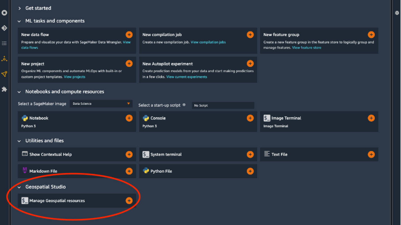
In our example, we work with the SageMaker geospatial SDK through programmatic or code interaction, because we’re interested in building code pipelines that can be automated with the different steps required in our process. Note you could also work with an UI through the graphical extensions provided with SageMaker geospatial in Amazon SageMaker Studio if you prefer this approach, as shown in the following screenshots. For accessing the Geospatial Studio UI, open the SageMaker Studio Launcher and choose Manage Geospatial resources. You can check more details in the documentation to Get Started with Amazon SageMaker Geospatial Capabilities.

Geospatial UI launcher

Geospatial UI main

Geospatial UI list of jobs

Here you can graphically create, monitor, and visualize the results of the Earth Observation jobs (EOJs) that you run with SageMaker geospatial features.

Back to our example, the first step for interacting with the SageMaker geospatial SDK is to set up the client. We can do this by establishing a session with the botocore library:

session = botocore.session.get_session()
gsClient = session.create_client(
    service_name='sagemaker-geospatial',
    region_name=region) #Replace with your region, e.g., 'us-east-1'

From this point on, we can use the client for running any EOJs of interest.

Obtaining data

For this use case, we start by collecting satellite imagery for our given geographical area. Depending on the location of interest, there might be more or less frequent coverage by the available satellites, which have its imagery organized in what is usually referred to as raster collections.

With the geospatial capabilities of SageMaker, you have direct access to high-quality data sources for obtaining the geospatial data directly, including those from AWS Data Exchange and the Registry of Open Data on AWS, among others. We can run the following command to list the raster collections already provided by SageMaker:

list_raster_data_collections_resp = gsClient.list_raster_data_collections()

This returns the details for the different raster collections available, including the Landsat C2L2 Surface Reflectance (SR), Landsat C2L2 Surface Temperature (ST), or the Sentinel 2A & 2B. Conveniently, Level 2A imagery is already optimized into Cloud-Optimized GeoTIFFs (COGs). See the following code:

…
{'Name': 'Sentinel 2 L2A COGs',
  'Arn': 'arn:aws:sagemaker-geospatial:us-west-2:378778860802:raster-data-collection/public/nmqj48dcu3g7ayw8',
  'Type': 'PUBLIC',
  'Description': 'Sentinel-2a and Sentinel-2b imagery, processed to Level 2A (Surface Reflectance) and converted to Cloud-Optimized GeoTIFFs'
…

Let’s take this last one for our example, by setting our data_collection_arn parameter to the Sentinel 2 L2A COGs’ collection ARN.

We can also search the available imagery for a given geographical location by passing the coordinates of a polygon we defined as our area of interest (AOI). This allows you to visualize the image tiles available that cover the polygon you submit for the specified AOI, including the Amazon Simple Storage Service (Amazon S3) URIs for these images. Note that satellite imagery is typically provided in different bands according to the wavelength of the observation; we discuss this more later in the post.

response = gsClient.search_raster_data_collection(**eoj_input_config, Arn=data_collection_arn)

The preceding code returns the S3 URIs for the different image tiles available, that you can directly visualize with any library compatible with GeoTIFFs such as rasterio. For example, let’s visualize two of the True Color Image (TCI) tiles.

…
'visual': {'Href': 'https://sentinel-cogs.s3.us-west-2.amazonaws.com/sentinel-s2-l2a-cogs/32/U/NC/2022/3/S2A_32UNC_20220325_0_L2A/TCI.tif'},
…

True Color Image 1True Color Image 2

Processing techniques

Some of the most common preprocessing techniques that we apply include cloud removal, geo mosaic, temporal statistics, band math, or stacking. All of these processes can now be done directly through the use of EOJs in SageMaker, without the need to perform manual coding or using complex and expensive third-party tools. This makes it 50% faster to build our data processing pipelines. With SageMaker geospatial capabilities, we can run these processes over different input types. For example:

  • Directly run a query for any of the raster collections included with the service through the RasterDataCollectionQuery parameter
  • Pass imagery stored in Amazon S3 as an input through the DataSourceConfig parameter
  • Simply chain the results of a previous EOJ through the PreviousEarthObservationJobArn parameter

This flexibility allows you to build any kind of processing pipeline you need.

The following diagram illustrates the processes we cover in our example.

Geospatial Processing tasks

In our example, we use a raster data collection query as input, for which we pass the coordinates of our AOI and time range of interest. We also specify a percentage of maximum cloud coverage of 2%, because we want clear and noise-free observations of our geographical area. See the following code:

eoj_input_config = {
    "RasterDataCollectionQuery": {
        "RasterDataCollectionArn": data_collection_arn,
        "AreaOfInterest": {
            "AreaOfInterestGeometry": {"PolygonGeometry": {"Coordinates": [coordinates]}}
        },
        "TimeRangeFilter": {"StartTime": time_start, "EndTime": time_end},
        "PropertyFilters": {
            "Properties": [
                {"Property": {"EoCloudCover": {"LowerBound": 0, "UpperBound": 2}}}
            ]
        },
    }
}

For more information on supported query syntax, refer to Create an Earth Observation Job.

Cloud gap removal

Satellite observations are often less useful due to high cloud coverage. Cloud gap filling or cloud removal is the process of replacing the cloudy pixels from the images, which can be done with different methods to prepare the data for further processing steps.

With SageMaker geospatial capabilities, we can achieve this by specifying a CloudRemovalConfig parameter in the configuration of our job.

eoj_config =  {
    'CloudRemovalConfig': {
        'AlgorithmName': 'INTERPOLATION',
        'InterpolationValue': '-9999'
    }
}

Note that we’re using an interpolation algorithm with a fixed value in our example, but there are other configurations supported, as explained in the Create an Earth Observation Job documentation. The interpolation allows it estimating a value for replacing the cloudy pixels, by considering the surrounding pixels.

We can now run our EOJ with our input and job configurations:

response = gsClient.start_earth_observation_job(
    Name =  'cloudremovaljob',
    ExecutionRoleArn = role,
    InputConfig = eoj_input_config,
    JobConfig = eoj_config,
)

This job takes a few minutes to complete depending on the input area and processing parameters.

When it’s complete, the results of the EOJ are stored in a service-owned location, from where we can either export the results to Amazon S3, or chain these as input for another EOJ. In our example, we export the results to Amazon S3 by running the following code:

response = gsClient.export_earth_observation_job(
    Arn = cr_eoj_arn,
    ExecutionRoleArn = role,
    OutputConfig = {
        'S3Data': {
            'S3Uri': f's3://{bucket}/{prefix}/cloud_removal/',
            'KmsKeyId': ''
        }
    }
)

Now we’re able to visualize the resulting imagery stored in our specified Amazon S3 location for the individual spectral bands. For example, let’s inspect two of the blue band images returned.

Alternatively, you can also check the results of the EOJ graphically by using the geospatial extensions available in Studio, as shown in the following screenshots.

Cloud Removal UI 1   Cloud Removal UI 2

Temporal statistics

Because the satellites continuously orbit around earth, the images for a given geographical area of interest are taken at specific time frames with a specific temporal frequency, such as daily, every 5 days, or 2 weeks, depending on the satellite. The temporal statistics process enables us to combine different observations taken at different times to produce an aggregated view, such as a yearly mean, or the mean of all observations in a specific time range, for the given area.

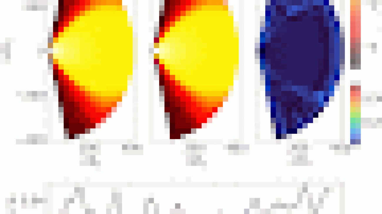
With SageMaker geospatial capabilities, we can do this by setting the TemporalStatisticsConfig parameter. In our example, we obtain the yearly mean aggregation for the Near Infrared (NIR) band, because this band can reveal vegetation density differences below the top of the canopies:

eoj_config =  {
    'TemporalStatisticsConfig': {
        'GroupBy': 'YEARLY',
        'Statistics': ['MEAN'],
        'TargetBands': ['nir']
    }
}

After a few minutes running an EOJ with this config, we can export the results to Amazon S3 to obtain imagery like the following examples, in which we can observe the different vegetation densities represented with different color intensities. Note the EOJ can produce multiple images as tiles, depending on the satellite data available for the time range and coordinates specified.

Temporal Statistics 1Temporal Statistics 2

Band math

Earth observation satellites are designed to detect light in different wavelengths, some of which are invisible to the human eye. Each range contains specific bands of the light spectrum at different wavelengths, which combined with arithmetic can produce images with rich information about characteristics of the field such as vegetation health, temperature, or presence of clouds, among many others. This is performed in a process commonly called band math or band arithmetic.

With SageMaker geospatial capabilities, we can run this by setting the BandMathConfig parameter. For example, let’s obtain the moisture index images by running the following code:

eoj_config =  {
    'BandMathConfig': {
        'CustomIndices': {
            'Operations': [
                {
                    'Name': 'moisture',
                    'Equation': '(B8A - B11) / (B8A + B11)'
                }
            ]
        }
    }
}

After a few minutes running an EOJ with this config, we can export the results and obtain images, such as the following two examples.

Moisture index 1Moisture index 2Moisture index legend

Stacking

Similar to band math, the process of combining bands together to produce composite images from the original bands is called stacking. For example, we could stack the red, blue, and green light bands of a satellite image to produce the true color image of the AOI.

With SageMaker geospatial capabilities, we can do this by setting the StackConfig parameter. Let’s stack the RGB bands as per the previous example with the following command:

eoj_config =  {
    'StackConfig': {
        'OutputResolution': {
            'Predefined': 'HIGHEST'
        },
        'TargetBands': ['red', 'green', 'blue']
    }
}

After a few minutes running an EOJ with this config, we can export the results and obtain images.

Stacking TCI 1Stacking TCI 2

Semantic segmentation models

As part of our work, we commonly use ML models to run inferences over the preprocessed imagery, such as detecting cloudy areas or classifying the type of land in each area of the images.

With SageMaker geospatial capabilities, you can do this by relying on the built-in segmentation models.

For our example, let’s use the land cover segmentation model by specifying the LandCoverSegmentationConfig parameter. This runs inferences on the input by using the built-in model, without the need to train or host any infrastructure in SageMaker:

response = gsClient.start_earth_observation_job(
    Name =  'landcovermodeljob',
    ExecutionRoleArn = role,
    InputConfig = eoj_input_config,
    JobConfig = {
        'LandCoverSegmentationConfig': {},
    },
)

After a few minutes running a job with this config, we can export the results and obtain images.

Land Cover 1Land Cover 2Land Cover 3Land Cover 4

In the preceding examples, each pixel in the images corresponds to a land type class, as shown in the following legend.

Land Cover legend

This allows us to directly identify the specific types of areas in the scene such as vegetation or water, providing valuable insights for additional analyses.

Bring your own model with SageMaker

If the state-of-the-art geospatial models provided with SageMaker aren’t enough for our use case, we can also chain the results of any of the preprocessing steps shown so far with any custom model onboarded to SageMaker for inference, as explained in this SageMaker Script Mode example. We can do this with any of the inference modes supported in SageMaker, including synchronous with real-time SageMaker endpoints, asynchronous with SageMaker asynchronous endpoints, batch or offline with SageMaker batch transforms, and serverless with SageMaker serverless inference. You can check further details about these modes in the Deploy Models for Inference documentation. The following diagram illustrates the workflow in high-level.

Inference flow options

For our example, let’s assume we have onboarded two models for performing a land cover classification and crop type classification.

We just have to point towards our trained model artifact, in our example a PyTorch model, similar to the following code:

from sagemaker.pytorch import PyTorchModel
import datetime

model = PyTorchModel(
    name=model_name, ### Set a model name
    model_data=MODEL_S3_PATH, ### Location of the custom model in S3
    role=role,
    entry_point='inference.py', ### Your inference entry-point script
    source_dir='code', ### Folder with any dependencies
    image_uri=image_uri, ### URI for your AWS DLC or custom container
    env={
        'TS_MAX_REQUEST_SIZE': '100000000',
        'TS_MAX_RESPONSE_SIZE': '100000000',
        'TS_DEFAULT_RESPONSE_TIMEOUT': '1000',
    }, ### Optional – Set environment variables for max size and timeout
)

predictor = model.deploy(
    initial_instance_count = 1, ### Your number of instances
    instance_type = 'ml.g4dn.8xlarge', ### Your instance type
    async_inference_config=sagemaker.async_inference.AsyncInferenceConfig(
        output_path=f"s3://{bucket}/{prefix}/output",
        max_concurrent_invocations_per_instance=2,
    ), ### Optional – Async config if using SageMaker Async Endpoints
)

predictor.predict(data) ### Your images for inference

This allows you to obtain the resulting images after inference, depending on the model you’re using.

In our example, when running a custom land cover segmentation, the model produces images similar to the following, where we compare the input and prediction images with its corresponding legend.

Land Cover Segmentation 1  Land Cover Segmentation 2. Land Cover Segmentation legend

The following is another example of a crop classification model, where we show the comparison of the original vs. resulting panoptic and semantic segmentation results, with its corresponding legend.

Crop Classification

Automating geospatial pipelines

Finally, we can also automate the previous steps by building geospatial data processing and inference pipelines with Amazon SageMaker Pipelines. We simply chain each preprocessing step required through the use of Lambda Steps and Callback Steps in Pipelines. For example, you could also add a final inference step using a Transform Step, or directly through another combination of Lambda Steps and Callback Steps, for running an EOJ with one of the built-in semantic segmentation models in SageMaker geospatial features.

Note we’re using Lambda Steps and Callback Steps in Pipelines because the EOJs are asynchronous, so this type of step allows us to monitor the run of the processing job and resume the pipeline when it’s complete through messages in an Amazon Simple Queue Service (Amazon SQS) queue.

Geospatial Pipeline

You can check the notebook in the GitHub repository for a detailed example of this code.

Now we can visualize the diagram of our geospatial pipeline through Studio and monitor the runs in Pipelines, as shown in the following screenshot.

Geospatial Pipeline UI

Conclusion

In this post, we presented a summary of the processes we implemented with SageMaker geospatial capabilities for building geospatial data pipelines for our advanced products from xarvio Digital Farming Solutions. Using SageMaker geospatial increased the efficiency of our geospatial work by more than 50%, through the use of pre-built APIs that accelerate and simplify our preprocessing and modeling steps for ML.

As a next step, we’re onboarding more models from our catalog to SageMaker to continue the automation of our solution pipelines, and will continue utilizing more geospatial features of SageMaker as the service evolves.

We encourage you to try SageMaker geospatial capabilities by adapting the end-to-end example notebook provided in this post, and learning more about the service in What is Amazon SageMaker Geospatial Capabilities?.


About the Authors

Julian BlauJulian Blau is a Data Scientist at BASF Digital Farming GmbH, located in Cologne, Germany. He develops digital solutions for agriculture, addressing the needs of BASF’s global customer base by using geospatial data and machine learning. Outside work, he enjoys traveling and being outdoors with friends and family.

Antonio RodriguezAntonio Rodriguez is an Artificial Intelligence and Machine Learning Specialist Solutions Architect in Amazon Web Services, based out of Spain. He helps companies of all sizes solve their challenges through innovation, and creates new business opportunities with AWS Cloud and AI/ML services. Apart from work, he loves to spend time with his family and play sports with his friends.

Read More

Unfolding the Universe using TensorFlow

Unfolding the Universe using TensorFlow

A guest post by Roberta Duarte, IAG/USP

Astronomy is the science of trying to answer the Universe’s biggest mysteries. How did the Universe begin? How will it end? What is a black hole? What are galaxies and how did they form? Is life a common piece in the Universe’s puzzle? There are so many questions without answers. Machine learning can be a vital tool to answer those questions and help us unfold the Universe.

Astronomy is one of the oldest sciences. The reason is simple: we just have to look at the sky and start questioning what we are seeing. It is what astronomers have been doing for centuries. Galileo discovered a series of celestial objects after he observed the sky through the lenses of his new invention: the telescope. A few years later, Isaac Newton used Galileo’s contributions to find the Law of Universal Gravitation. With Newton’s results, we could not only understand better how the Sun affects Earth and other planets but also why we are trapped on Earth’s surface. Centuries later, Edwin Hubble found that galaxies are moving away from us and that further galaxies are moving faster than closer ones. Hubble’s findings showed that the Universe is expanding and is accelerated. These are a few examples of how studying the sky can give us some answers about the universe.

What all of them have in common is that they record data obtained from observations. The data can be a star’s luminosity, planets’ positions, or even galaxies’ distances. With technology improving the observations, more data is available to help us understand the Universe around us. Recently, the most advanced telescope, James Webb Space Telescope (JWST), was launched to study the early Universe in infrared. JWST is expected to transmit 57.2 gigabytes per day of data containing information about early galaxies, exoplanets, and the Universe’s structure.

While this is excellent news for astronomers, it also comes with a high cost. A high computational cost. In 2020, Nature published an article about big data and how Astronomy is now in an era of big data. JWST is one of the examples of how those powerful telescopes are producing huge amounts of data every day. Vera Rubin Observatory is expected to collect 20 terabytes per night. Large Arrays collect petabytes of data every year, and next-generation Large Arrays will collect hundreds of petabytes per year. In 2019, several Astro White Papers were published with the goals and obstacles in the Astronomy field predicted for the 2020s. They outlined how Astronomy needs to change in order to be prepared for the huge volume of data expected during the 2020s. New methods are required since the traditional cannot deal with the expressive number. We see problems showing up when talking about storage, software, and processing.

The storage problem may have a solution in cloud computing, eg. GCP, as noted by Nature. However, processing does not have a simple solution. The methods used to process and analyze the data need to change. It is important to note that Astronomy is a science based on finding patterns. Stars with the same redshift – an estimation of the distance of stars in space relative to us by measuring the shift of the star’s light waves towards higher frequencies – and similar composition can be considered candidates for the same population. Galaxies with the same morphology and activity or spectrum originating in the nucleus usually show the presence of black holes with similar behavior. We can even calculate the Universe’s expansion rate by studying the pattern in the spectra of different Type I Supernovae. And, what is the best tool we have to learn patterns in a lot of data? Machine Learning.

Machine learning is a tool that Astronomy can use to deal with the computational problems cited above. A data-driven approach offered by machine learning techniques may help to get analysis and results faster than traditional methods such as numerical simulations or MCMC – a statistical method of sampling from a probability distribution. In the past few years, we are seeing an interesting increase in the interaction between Astronomy and machine learning. To quantify, the keyword machine learning presented in Astronomy’s papers increased four times from 2015 to 2020 while deep learning increased 3 times each year. More specifically, machine learning was widely used to classify celestial objects and to predict spectra from given properties. Today, we see a large range of applications since discovering exoplanets, simulations of the Universe’s cosmic web, and searching for gravitational waves.

Since machine learning offers a data-driven approach, it can accelerate scientific research in the field. An interesting example is the research around black holes. Black holes have been a hot topic for the past few years with amazing results and pictures from the Event Horizon Telescope (EHT). To understand a black hole, we need the help of computational tools. A black hole is a region of spacetime extremely curved that nothing, not even light, can escape. When matter gets trapped around its gravitational field, the matter will create a disk called accretion disk. The accretion disk dynamics are chaotic and turbulent. To understand the accretion disk physics, we need to simulate complex fluid equations. 
A common method to solve this and gain insight into black hole physics is to use numerical simulations. The environment around a black hole can be described using a set of conservative equations – usually, mass conservation, energy conservation, and angular momentum conservation. The set of equations can be solved using numerical and mathematical methods that iteratively solve each parameter for each time. The result is a set of dumps – or frames – with information about density, pressure, velocity field, and magnetic field for each (x, y, t) in the 2D case or (x, y, z, t) in the 3D case. However, numerical simulations are very time-consuming. A simple hydrodynamical treatment around a black hole can go up to 7 days running on 400 CPU cores.

If you start adding complexity, such as electromagnetism equations to understand the magnetic fields around a black hole and general relativity equations to realistically explain the space-time there, the time can increase significantly. We are slowly reaching a barrier in black hole physics due to computational limitations where it is becoming harder and harder to realistically simulate a black hole.

Black hole research

That is where my advisor, Rodrigo Nemmen, and I started to think about a new method to accelerate black hole physics. In other words, a new method that could accelerate the numerical simulations we needed to study these extreme objects. From the beginning machine learning seems like the method with the best perspective for us. We had the data to feed into a machine learning algorithm and there were successful cases in the literature simulating fluids using machine learning. But never around a black hole. It was worth giving it a shot. We began a collaboration with João Navarro from Nvidia Brazil and then we started solving the problem. Carefully, we chose an architecture that we would be based on while building our own scheme. Since we wanted a data-driven approach, we decided to go with supervised learning, more specifically, we decided to use deep learning linked with the great performance of convolutional neural networks.

How we built it

Everything was built using TensorFlow and Keras. We started using TensorFlow 1 since it was the version available at the time. Back then, Keras was not added to TensorFlow yet but funny enough, during that time I attended the TensorFlow Roadshow 2019 in São Paulo, Brazil. It was during that event that I found out about TensorFlow and Keras joining forces in TensorFlow version 2 to create the powerful framework. I even took a picture of the announcement. Also, it was the first time I heard about the strategy scope implemented in TensorFlow 2, I did not know back then that I would be using the same function today.
It needed weeks to deal with the data and to know the best way to prepare before we could feed them to ConvNets. The data described the density of a fluid around a black hole. In our case, we got the data from sub-fed black holes, in other words, black holes with low accretion rates. Back in 2019, the simulations we used were the longest simulations of this kind – 2D profiles using a hydrodynamical treatment. The process that we went through is described in Duarte et al. 2022. We trained our ConvNet with 2D spatial + 1D temporal dimensions. A cluster with two GPUs (NVIDIA G100 and NVIDIA P6000) was our main hardware to train our neural network.
After a few hours of training, our model was ready to simulate black holes. First, we tested the capacity by testing how much the model can learn the rest of the learned simulation. The video shows the target and prediction for a case that we called a direct case: we feed a simulation frame to the model as input and we analyze how well the model can predict the next step.
But we also want to see how much of the Physics the model could learn by only looking at some simulations. We test the model capacity to simulate a never-seen system. During the training process, we hid a simulation from the model. After the training, we input the initial conditions and a single frame so we could test how the model would perform while simulating by itself. The results are great news: the model can simulate a system by only learning Physics from other ones. And the news gets better: you have a 32000x speed-up compared to traditional methods.

Just out of curiosity, we tested a direct prediction from a system where the accretion flow around the black hole has high variability. It’s a really beautiful result to see how the model could follow the turbulent behavior of the accretion flow.

If you are interested in more details and results, they are available at Duarte et al. 2022.

This work demonstrates the power of using deep learning techniques in Astronomy to speed up scientific research. All the work was done using only TensorFlow tools to preprocess, train and predict. How great is that?

Conclusion

As we discussed in this post, AI is already an essential part of Astronomy and we can expect that it will only continue to grow. We have already seen that Astronomy can achieve big wins with the help of AI. It is a field with a lot of data and patterns that are perfect to build and test AI tools using real-world data. There will come a day that AI will be discovering and unfolding the Universe and hopefully, this day is soon!

Read More

Meet the Omnivore: Cloud Architect Takes Infrastructure Visualization to New Heights With NVIDIA Omniverse

Meet the Omnivore: Cloud Architect Takes Infrastructure Visualization to New Heights With NVIDIA Omniverse

Editor’s note: This post is a part of our Meet the Omnivore series, which features individual creators and developers who use NVIDIA Omniverse to accelerate their 3D workflows and create virtual worlds.

As a Microsoft Certified Azure cloud specialist and DevOps automation engineer, Gavin Stevens is deeply in tune with cloud architect workflows.

He noticed an opportunity to improve the abilities of cloud architects to visualize their infrastructure — the combination of hardware and software necessary for cloud computing — by creating a 3D layout of it.

So Stevens set out to enable this by building an extension for NVIDIA Omniverse — a platform for connecting and building custom 3D pipelines and metaverse applications.

Dubbed Meta Cloud Explorer, the open-source extension generates digital 3D models of engineers’ cloud infrastructure components at scale, based on contextual metadata from their Azure cloud portals.

The visualization can then be organized by group, location, subscription and resource type. It also displays infrastructure layouts and costs on various planes. This can help cloud architects gain insights to optimize resources, reduce costs and improve customer experiences.

“There’s no shortage of ‘infrastructure diagram generation’ tools that can produce 2D representations of your cloud infrastructure,” Stevens said. “But most of these tools present a tightly focused exploration context, where it’s difficult to see your infrastructure at scale.”

Meta Cloud Explorer, instead, displays 3D representations that can be rearranged at scale. It’s one of the winning submissions for the inaugural #ExtendOmniverse contest, where developers were invited to create their own Omniverse extension for a chance to win an NVIDIA RTX GPU.

Omniverse extensions are core building blocks that let anyone create and extend functions of Omniverse apps using the popular Python and C++ programming languages.

Building Custom Workflow Tools

Stevens, who’s based in Scottsdale, Arizona, learned how to build the Omniverse extension in just a few months by attending community livestreams, learning Python and prototyping user interfaces based on sample resources.

He first transformed Microsoft Azure’s open-source 2D icons — representing storage accounts, web apps, databases and more — into 3D assets using Blender software. He easily brought these into Omniverse with Universal Scene Description (USD), an open-source, extensible file framework that serves as the common language for building virtual worlds and the metaverse.

Stevens then composed a 3D layout, arranging and visualizing the infrastructure services based on data such as location, type and cost by implementing a custom packing and layout algorithm. He also created a user interface directly in the scene to display details such as a cluster’s total cost or a service’s status.

“Omniverse takes care of the rendering and helps developers work at a higher level to easily visualize things in a 3D space,” Stevens said. “And USD makes it seamless to reference and position 3D objects within scenes.”

Dive deeper into Stevens’ workflow by watching this video:

Stevens is now planning to expand Meta Cloud Explorer’s capabilities to build an advanced software-as-a-service that enables users to create infrastructure from template libraries, learn about new architecture techniques and simulate design changes.

Being able to manipulate cloud infrastructure layouts in 3D, or even in virtual reality, would open up new possibilities for developers and cloud engineers to realize a customer’s vision, Stevens said.

“I’m not sure how you could even do this without Omniverse,” he added. “Omniverse Kit provides a dynamic, easy-to-use platform for building metaverse applications. And the ability to connect external application programming interfaces and data sources opens up flexibility when using Omniverse.”

Developers like Stevens can enhance their workflows with the recent Omniverse beta release, which includes major updates to core reference applications and tools for developers, creators and novices looking to build metaverse applications.

Join In on the Creation

Creators and developers across the world can download NVIDIA Omniverse for free, and enterprise teams can use the platform for their 3D projects.

Discover how to build an Omniverse extension in less than 10 minutes.

To find out how to accelerate cloud workflows, join NVIDIA at AWS re:Invent, running through Friday, Dec. 2.

For a deeper dive into developing on Omniverse, watch the on-demand NVIDIA GTC session, “How to Build Extensions and Apps for Virtual Worlds With NVIDIA Omniverse.”

Find additional documentation and tutorials in the Omniverse Resource Center, which details how developers can build custom USD-based applications and extensions for the platform.

To discover more free tools, training and a community for developers, join the NVIDIA Developer Program.

Follow NVIDIA Omniverse on Instagram, Medium, Twitter and YouTube for additional resources and inspiration. Check out the Omniverse forums, and join our Discord server and Twitch channel to chat with the community.

The post Meet the Omnivore: Cloud Architect Takes Infrastructure Visualization to New Heights With NVIDIA Omniverse appeared first on NVIDIA Blog.

Read More

Cheers to AI: Monarch Tractor Launches First Commercially Available Electric, ‘Driver Optional’ Smart Tractor

Cheers to AI: Monarch Tractor Launches First Commercially Available Electric, ‘Driver Optional’ Smart Tractor

Livermore, Calif., renowned for research and vineyards, is plowing in a new distinction: the birthplace of the first commercially available smart tractor.

Local startup Monarch Tractor has announced the first of six Founder Series MK-V tractors are rolling off the production line at its headquarters. Constellation Brands, a leading wine and spirits producer and beer importer, will be the first customer given keys  at a launch event today.

The debut caps a two-year development sprint since Monarch, founded in 2018, hatched plans to deliver its smart tractor, complete with the energy-efficient NVIDIA Jetson edge AI platform. The tractor combines electrification, automation, and data analysis to help farmers reduce their carbon footprint, improve field safety, streamline farming operations, and increase their bottom lines.

The MK-V tractor cuts energy costs and diesel emissions, while also helping reduce harmful herbicides, which are expensive and deplete the soil.

“With precision ag, autonomy and AI, data will decrease the volume of chemicals used, which is good for the soil, good for the farmer from a profitability standpoint, and good for the consumer,” said Praveen Penmetsa, CEO of Monarch Tractor.

The delivery of MK-V tractors to Constellation Brands will be followed with additional tractor shipments to family farms and large corporate customers, according to the company.

Monarch is a member of the NVIDIA Inception program, which provides startups with technology support and AI platforms guidance.

Leading Farming AI Wave of Clean Tractors

Monarch Tractor founders include veterans of Silicon Valley’s EV scene who worked together at startup Zoox, now Amazon owned. Carlo Mondavi, from the Napa Valley Mondavi winery family, is a sustainability-focused vintner and chief farming officer.  Mark Schwager, former Tesla Gigafactory chief, is president; Zachary Omohundro, a robotics Ph.D. from Carnegie Mellon, is CTO; Penmetsa is an autonomy and mobility engineer.

“The marriage of NVIDIA accelerated computing with Jetson edge AI on our Monarch MK-V has helped our customers reduce the use of unneeded herbicides with our cutting-edge, zero-emission tractor – this revolutionary technology is helping our planet’s soil, waterways and biodiversity,” said Carlo Mondavi.

Penmetsa likens the revolutionary new tractor to paradigm shifts in PCs and smartphones, enablers of world-changing applications. Monarch’s role, he said, is as the hub to enable smart implements — precision sprayers, harvesters and more — for computer vision applications to help automate farming.

In 2021, Monarch launched pilot test models for commercial use at Wente Vineyards, also based in Livermore. The trial at Wente compared its energy usage to that of a diesel tractor, noting Monarch saved more than $2,600 in annual expenses.

Monarch has raised more than $110 million in funding. Strategic investors include Japanese auto parts maker Musashi Seimitsu Industry Co; CNH Industrial, an agricultural equipment maker; and VST Tillers Tractors, an India-based equipment maker and dealer of tractors and implements.

It recently signed a contract manufacturing agreement with Hon Hai Technology Group Foxconn to build the MK-V and its battery packs at the Mahoning Valley, Ohio, plant.

As a wave of AI sweeps farming, developers are working to support more sustainable farming practices.

The NVIDIA Jetson platform provides energy-efficient computing to the MK-V, which offers advances in battery performance.

What a Jetson-Supported Monarch Founder Series MK-V Can Do

Tapping into six NVIDIA Jetson Xavier NX SOMs (system on modules), Monarch’s Founder Series MK-V tractors are essentially roving robots packing supercomputing.

Monarch has harnessed Jetson to deliver tractors that can safely traverse rows within agriculture fields using only cameras. “This is important in certain agriculture environments because there may be no GPS signal,” said Penmetsa. “It’s also crucial for safety as the Monarch is intended for totally driverless operation.”

The Founder Series MK-V runs two 3D cameras and six standard cameras. With the six Jetson edge AI modules on board, it can run models for multiple farming tasks when paired with different implements.

Supporting more sustainable farming practices, computer vision applications are available to fine-tune with transfer learning for the Monarch platform to develop precision spraying and other options.

Delivering Farm-Apps-as-a-Service 

Monarch offers a core of main applications to assist farms with AI, available in a software-as-a-service model on its platform.

The Founder Series MK-V has some basic functions on its platform as well, such as sending alerts when on a low charge or there’s an unidentified object obstructing a path. It will also shut down from spraying if its camera-based vision platform identifies a human.

The tractor collects and analyzes crop data daily and can process data from current and next-generation implements equipped with sensors and imaging. This data can be used for real-time implement adjustments, long-term yield estimates, current growth stages and other plant and crop health metrics.

Wider availability of the tractor begins a new chapter in improved farming practices.

“The marriage of NVIDIA accelerated computing with Jetson edge AI on our Monarch MK-V has helped our customers reduce the use of unneeded herbicides with our cutting-edge, zero-emission tractor – this revolutionary technology is helping our planet’s soil, waterways and biodiversity,” said Mondavi.

Learn more about NVIDIA Isaac platform for robotics and apply to join NVIDIA Inception.

The post Cheers to AI: Monarch Tractor Launches First Commercially Available Electric, ‘Driver Optional’ Smart Tractor appeared first on NVIDIA Blog.

Read More

Protecting Consumers and Promoting Innovation – AI Regulation and Building Trust in Responsible AI

Protecting Consumers and Promoting Innovation – AI Regulation and Building Trust in Responsible AI

Artificial intelligence (AI) is one of the most transformational technologies of our generation and provides huge opportunities to be a force for good and drive economic growth. It can help scientists cure terminal diseases, engineers build inconceivable structures, and farmers yield more crops. AI allows us to make sense of our world as never before—and build products and services to address some of our most challenging problems, like climate change and responding to humanitarian disasters. AI is also helping industries innovate and overcome more commonplace challenges. Manufacturers are deploying AI to avoid equipment downtime through predictive maintenance and streamlining their logistics and distribution channels through supply chain optimization. Airlines are taking advantage of AI technologies to enhance the customer booking experience, assist with crew scheduling, and transporting passengers with greater fuel efficiency by simulating routes based on distance, aircraft weight, and weather.

While the benefits of AI are already plain to see and improving our lives each day, unlocking AI’s full potential will require building greater confidence among consumers. That means earning public trust that AI will be used responsibly and in a manner that is consistent with the rule of law, human rights, and the values of equity, privacy, and fairness.

Understanding the important need for public trust, we work closely with policymakers across the country and around the world as they assess whether existing consumer protections remain fit-for-purpose in an AI era. An important baseline for any regulation must be to differentiate between high-risk AI applications and those that pose low-to-no risk. The great majority of AI applications fall in the latter category, and their widespread adoption provides opportunities for immense productivity gains and, ultimately, improvements in human well-being. If we are to inspire public confidence in the overwhelmingly good, businesses must demonstrate they can confidently mitigate the potential risks of high-risk AI. The public should be confident that these sorts of high-risk systems are safe, fair, appropriately transparent, privacy protective, and subject to appropriate oversight.

At AWS, we recognize that we are well positioned to deliver on this vision and are proud to support our customers as they invent, build, and deploy AI systems to solve real-world problems. As AWS offers the broadest and deepest set of AI services and the supporting cloud infrastructure, we are committed to developing fair and accurate AI services and providing customers with the tools and guidance needed to build applications responsibly. We recognize that responsible AI is the shared responsibility of all organizations that develop and deploy AI systems.

We are committed to providing tools and resources to aide customers using our AI and machine learning (ML) services. Earlier this year, we launched our Responsible Use of Machine Learning guide, providing considerations and recommendations for responsibly using ML across all phases of the ML lifecycle. In addition, at our 2020 AWS re:Invent conference, we rolled out Amazon SageMaker Clarify, a service that provides developers with greater insights into their data and models, helping them understand why an ML model made a specific prediction and also whether the predictions were impacted by bias. Additional resources, access to AI/ML experts, and education and training can also be found on our Responsible use of artificial intelligence and machine learning page.

We continue to expand efforts to provide guidance and support to customers and the broader community in the responsible use space. This week at our re:Invent 2022 conference, we announced the launch of AWS AI Service Cards, a new transparency resource to help customers better understand our AWS AI services. The new AI Service Cards deliver a form of responsible AI documentation that provide customers with a single place to find information.

Each AI Service Card covers four key topics to help you better understand the service or service features, including intended use cases and limitations, responsible AI design considerations, and guidance on deployment and performance optimization. The content of the AI Service Cards addresses a broad audience of customers, technologists, researchers, and other stakeholders who seek to better understand key considerations in the responsible design and use of an AI service.

Conversations among policymakers regarding AI regulations continue as the technologies become more established. AWS is focused on not only offering the best-in-class tools and services to provide for the responsible development and deployment of AI services, but also continuing our engagement with lawmakers to promote strong consumer protections while encouraging the fast pace of innovation.


About the Author

Nicole Foster is Director of AWS Global AI/ML and Canada Public Policy at Amazon, where she leads the direction and strategy of artificial intelligence public policy for Amazon Web Services (AWS) around the world as well as the company’s public policy efforts in support of the AWS business in Canada. In this role, she focuses on issues related to emerging technology, digital modernization, cloud computing, cyber security, data protection and privacy, government procurement, economic development, skilled immigration, workforce development, and renewable energy policy.

Read More

GFN Thursday Dashes Into December With 22 New Games, Including ‘Marvel Midnight Suns’ Streaming Soon

GFN Thursday Dashes Into December With 22 New Games, Including ‘Marvel Midnight Suns’ Streaming Soon

It’s a new month, which means GeForce NOW’s got the list of 22 new games arriving in December.

Rise up for Marvel’s Midnight Suns, from publisher 2K Games, streaming on GeForce NOW later this month.

Then get ready to move out, members. Battlefield 2042 is the latest game from the Electronic Arts catalog streaming on GeForce NOW. It arrives just in time for the free access weekend, running Dec. 1-4, and comes with a members-only reward.

These games lead the charge, among the six additions streaming this week.

Time to Assemble 

From the creators of XCOM, and published by 2K Games, Marvel’s Midnight Suns is a tactical role-playing game set in the darker, supernatural side of the Marvel Universe. It launches on Steam on Friday, Dec. 2, with GeForce NOW members getting into the action later this month.

Marvels Midnight Suns
A new Sun must rise.

Play as “The Hunter,” a legendary demon slayer with a mysterious past and the first-ever customizable superhero in the Marvel Universe. Put together a team of legendary Marvel heroes, including Scarlet Witch, Spiderman, Wolverine, Blade and Captain America.

These heroes must fight together to stop the Mother of Demons from completing an ancient prophecy. In revolutionary card-based tactical battles, players can use ability cards on enemies, themselves or the environment.

Stay tuned for updates on the game’s release on GeForce NOW.

Step Foot Onto the Battlefield

Prepare to charge into Battlefield 2042, the first-person shooter that marks the return to the iconic all-out warfare of the widely popular franchise from Electronic Arts. Available today along with the latest update, “Season 3: Escalation,” the game marks the 19th title from EA to join GeForce NOW.

Adapt and overcome in a near-future world transformed by disorder. Choose your role on the battlefield with class specialists and form a squad to bring a cutting-edge arsenal into dynamically changing battlegrounds of unprecedented scale and epic destruction.

With RTX ON, EA and DICE introduced ray-traced ambient occlusion in Battlefield 2042. This accurately adds shadows where game elements occlude light, whether between a soldier and a wall, a tank and the tarmac, or foliage and the ground. Members can use NVIDIA DLSS to get the definitive PC experience, with maxed-out graphics, high frame rates and uncompromised image quality.

The game comes with a special reward for GeForce NOW members. To opt in and receive rewards, log in to your NVIDIA account and select “GEFORCE NOW” from the header, then scroll down to “REWARDS” and click the “UPDATE REWARDS SETTINGS” button. Check the box in the dialogue window that shows up to start receiving special offers and in-game goodies.

Experience the action across compatible devices and take gaming to the max with all the perks of an RTX 3080 membership, like 4K resolution, RTX ON and maximized gaming sessions.

The More the Merrier

The Knight Witch on GeForce NOW
Cast devastating card-based spells, forge close bonds and make moral choices — all in a quest to save your home.

Members can look for the following six games available to play this week:

  • The Knight Witch (New release on Steam, Nov. 29)
  • Warhammer 40,000: Darktide (New Release on Steam, Nov. 30)
  • Fort Triumph (Free on Epic Games Store, Dec. 1-8)
  • Battlefield 2042 (Steam and Origin)
  • Alien Swarm: Reactive Drop (Steam)
  • Stormworks: Build and Rescue (Steam)

Then time to unwrap the rest of the list of 22 games coming this month: 

  • Marvel’s Midnight Suns (New release on Steam, coming soon)
  • Art of the Rail (New release on Steam, Dec. 4)
  • Swordship (New release on Steam, Dec. 5)
  • Knights of Honor II: Sovereign (New release on Steam, Dec. 6)
  • Chained Echoes (New release on Steam, Dec. 7)
  • IXION (New release on Steam, Dec. 7)
  • Togges (New release on Steam, Dec. 7)
  • SAMURAI MAIDEN (New release on Steam, Dec. 8)
  • Wavetale (New release on Steam, Dec. 12)
  • Master of Magic (New release on Steam, Dec. 13)
  • BRAWLHALLA (Ubisoft Connect)
  • Carrier Command 2  (Steam)
  • Cosmoteer: Starship Architect & Commander (Steam)
  • Dakar Desert Rally (Epic Game Store)
  • Dinkum (Steam)
  • Floodland (Steam)
  • Project Hospital (Steam)

Nothing Left Behind From November

On top of the 26 games announced in November, members can play the extra 10 games that were added to GeForce NOW last month:

And good things come in small packages — for the perfect stocking stuffer or last-minute gift, look no further than GeForce NOW. Physical or digital gift cards are always available, and tomorrow is the last day to get in on the “Green Thursday Black Friday” deal.

Before you start off a super weekend of gaming, there’s only one choice left to make. Let us know your pick on Twitter or in the comments below.

The post GFN Thursday Dashes Into December With 22 New Games, Including ‘Marvel Midnight Suns’ Streaming Soon appeared first on NVIDIA Blog.

Read More